
Last Updated on July 24, 2026 by Daniel Globe
Planning a California National Parks road trip is exciting, but California’s size and wildly different climates make it easy to overpack an itinerary. The state’s nine national parks stretch from misty redwood forests near the Oregon border to the deserts of Southern California and islands off the coast. The best trip gives each region enough time instead of turning every day into a race to the next parking lot.
Quick Answer
For a manageable California National Parks road trip, allow about 18–21 days for all nine parks and build the route around season as well as mileage. A practical loop links Redwood, Lassen, Yosemite, Sequoia, Kings Canyon, Death Valley, Joshua Tree, Channel Islands, and Pinnacles, with Lake Tahoe as an optional detour.
Key Takeaways
- California has nine national parks, and a comfortable all-parks road trip generally deserves about three weeks rather than a rushed week or two.
- There is no perfect season for every park: Sierra snow, desert heat, wildfire smoke, and coastal conditions can all affect the route.
- In 2026, the America the Beautiful Annual Pass is $80 for eligible U.S. residents and $250 for nonresidents.
- Yosemite does not require a vehicle-entry reservation in 2026, but camping, lodging, wilderness trips, and some activities still require reservations or permits.
- Check individual NPS alerts shortly before every transfer because road, trail, fire, ferry, and weather conditions can change quickly.
At a Glance
| Time Required | About 18–21 days for all nine parks; longer if you want major hikes, rest days, or Lake Tahoe |
| Difficulty | Moderate to challenging because of long transfers, changing elevations, desert heat, and seasonal mountain roads |
| Tools Needed | Route planner, downloaded offline maps, NPS app or park maps, refillable water containers, sun protection, emergency supplies, and a road-ready vehicle |
| Cost | Varies widely. In 2026, the America the Beautiful Annual Pass is $80 for eligible U.S. residents and $250 for nonresidents, plus fuel, lodging or camping, food, and Channel Islands boat transportation. |
Disclosure: As an Amazon Associate I earn from qualifying purchases. Some links on this page are affiliate links, at no extra cost to you.
Planning Your California National Parks Road Trip
Start by deciding whether you really want to visit all nine national parks on one trip. California’s national parks are Redwood, Lassen Volcanic, Yosemite, Sequoia, Kings Canyon, Death Valley, Joshua Tree, Channel Islands, and Pinnacles. A statewide trip can be rewarding, but it covers a tremendous range of terrain and climate.
Choose Your Route Before Booking Lodging
Google Maps works well for basic routing, while Roadtrippers can organize multi-stop trips and offers larger waypoint limits on its paid plans. Whichever planner you use, treat drive-time estimates as a starting point rather than a schedule. Mountain roads, construction, traffic, weather, scenic stops, and park entrances can make a transfer take much longer than expected.
A sensible loop from the San Francisco area can run north to Redwood, east to Lassen, south through Yosemite and Sequoia/Kings Canyon, across to Death Valley and Joshua Tree, west to Ventura for Channel Islands, then north to Pinnacles before returning toward the Bay Area.
Pro Tip: Avoid scheduling a major hike on the same day as a long park-to-park drive. Even when a route looks manageable on a map, fuel stops, roadwork, viewpoints, food breaks, and slow mountain roads can consume hours.
Pick the Season Carefully
There is no single month when every California national park is at its best. Lassen, Yosemite, Sequoia, and Kings Canyon can retain snow well into spring, and high-elevation roads may open late after snowy winters. By contrast, Death Valley and Joshua Tree can become dangerously hot during summer.
For that reason, a full nine-park trip is always a compromise. Late spring can offer waterfalls and greener landscapes but may limit high-country access. Early fall can provide better mountain access, but desert heat, wildfire activity, and smoke may still be concerns. Always check each park’s current conditions shortly before travel.
Warning: Do not treat Death Valley as a normal summer hiking destination. The National Park Service advises against hiking at lower elevations during summer heat. Joshua Tree also experiences extreme summer temperatures and may impose seasonal trail, campground, and fire restrictions.
Understand the 2026 Park Pass Rules
The America the Beautiful Annual Pass can be useful on a multi-park trip, but the price changed for some travelers in 2026. The annual pass costs $80 for eligible U.S. residents and $250 for nonresidents. Compare the pass cost with the entrance fees for the parks you plan to visit rather than assuming it will always be the cheapest option.
Check Reservations and Permits Park by Park
Entrance rules are not identical across the parks and can change by year. For example, Yosemite does not require a vehicle-entry reservation in 2026, but campground and lodging reservations are strongly recommended, wilderness permits are required for overnight backcountry travel, and a permit is required to hike Half Dome when the cables are up.
Channel Islands also requires more advance planning than a typical drive-in park because most visitors need scheduled boat transportation. Reserve transportation and accommodation before locking in the surrounding road-trip dates.
Day-by-Day Itinerary Overview
This 20-day outline favors a steady pace over racing between entrance signs. It can be shortened, but cutting several days means spending less time hiking and more time driving.
Days 1–4: San Francisco to Redwood National and State Parks
Day 1: Arrive in the San Francisco area, pick up your vehicle, buy groceries and water, download offline maps, and review current NPS alerts.
Day 2: Drive north toward the Redwood National and State Parks corridor. Treat this as one of the trip’s longer transfer days rather than trying to squeeze in a major hike after arrival.
Days 3–4: Explore old-growth redwood forests, coastal viewpoints, prairie landscapes, and shorter hiking trails. Redwood is jointly managed by the National Park Service and California State Parks, so check both park information and road conditions when planning your stops.
Days 5–6: Lassen Volcanic National Park
Day 5: Travel inland toward Lassen Volcanic National Park.
Day 6: Explore Lassen’s volcanic landscape, hydrothermal areas, lakes, and mountain scenery. Kings Creek Falls can be a worthwhile hiking option when the trail is open and conditions are suitable.
Snow is a serious planning factor here. The park highway closes during the snowy season, and its full reopening date varies from year to year. Check the current Lassen conditions before building your route around a through-drive.
Days 7–9: Yosemite National Park
Day 7: Drive toward Yosemite. An optional Lake Tahoe stop can be inserted between Lassen and Yosemite, but add at least another night if you want more than a quick viewpoint stop.
Note: Emerald Bay at Lake Tahoe is Emerald Bay State Park, not a national park. It makes a beautiful optional detour, but it should not be counted among California’s nine national parks.
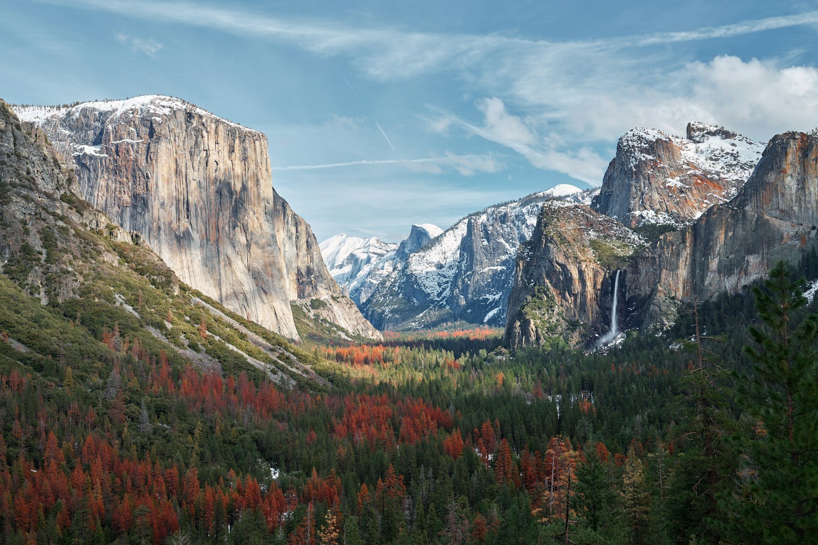
Days 8–9: Give Yosemite at least two exploration days. Depending on trail and road conditions, options include Lower Yosemite Fall, Yosemite Valley viewpoints, the Mist Trail, Mariposa Grove, and Glacier Point when the road is open.
Yosemite is one of the places where an extra day pays off. Parking and traffic can be heavy during popular periods, and rushing through the valley often means seeing more brake lights than scenery.
Days 10–12: Sequoia and Kings Canyon National Parks
Day 10: Transfer south toward Sequoia and Kings Canyon and settle into your lodging or campground.
Day 11: Explore Sequoia National Park. The General Sherman Tree is the largest tree in the world by trunk volume. Moro Rock and the Giant Forest area are other major stops when conditions allow.
Day 12: Spend the day in Kings Canyon National Park, with time for Grant Grove, the General Grant Tree, viewpoints, and accessible portions of the canyon depending on seasonal road conditions.
Days 13–14: Death Valley National Park
Day 13: Travel toward Death Valley and plan your sightseeing around the temperature. Sunset viewpoints and evening stargazing are especially appealing when skies are clear.
Day 14: Visit places such as Badwater Basin, Zabriskie Point, Mesquite Flat Sand Dunes, and other developed-road viewpoints that match current weather and road conditions.
Death Valley’s scale is easy to underestimate. Attractions that appear close together on a park map can still require substantial driving, so avoid packing too many stops into a single day.
Days 15–16: Joshua Tree National Park
Day 15: Drive south toward Joshua Tree and explore during the cooler part of the day.
Day 16: Allow a full day for the park’s Joshua tree woodlands, boulder formations, desert scenery, viewpoints, and hiking trails appropriate for the weather.
In hot weather, plan outdoor activity for early morning or later in the day, carry ample water, and follow current park restrictions.
Days 17–18: Channel Islands National Park
Day 17: Drive to the Ventura area and stay near your departure harbor. Confirm your boat reservation and prepare food, water, layers, and anything else you will need on the island.
Day 18: Take a day trip to one of the accessible islands, such as Santa Cruz or Anacapa, according to the current transportation schedule.
The islands are not connected to the mainland by road. According to the National Park Service transportation guidance, visitors can arrive by authorized concessionaire boat or private boat. Once ashore, there is no public ground transportation, so expect to travel on foot unless your activity involves a private boat or kayak.
Days 19–20: Pinnacles National Park and Return
Day 19: Drive north to Pinnacles National Park. Choose your entrance before setting out because the east and west entrances are not connected by a road through the park. Hiking options include the High Peaks area and, when open, the park’s talus caves.
Day 20: Enjoy another morning in Pinnacles or begin the return trip toward San Francisco, Monterey, or your departure airport.
If you only have 10–14 days, a better strategy is usually to choose a region instead of trying to check off all nine parks. For example, combine the Sierra and northern parks on one trip and save Death Valley, Joshua Tree, Channel Islands, and Pinnacles for another.
Key Highlights of Each National Park
Redwood National and State Parks
Come for the immense coast redwoods, but leave room for the coast, rivers, prairies, and wildlife. The parks cover more than one compact grove, so choose a few areas rather than trying to drive every scenic road in one day.
Lassen Volcanic National Park
Lassen combines volcanic peaks, lakes, hydrothermal features, and high-elevation scenery. Snow can restrict access well into the warmer part of the year, so current road status matters as much as your planned hiking list.
Yosemite National Park
Yosemite Valley delivers the famous granite cliffs and waterfalls, but the park extends far beyond the valley. Depending on the season, Mariposa Grove, Glacier Point, Tioga Road, and the high country can add a completely different experience.
Sequoia National Park
The Giant Forest and General Sherman Tree are the headline attractions. The surrounding landscape also includes mountain trails, granite formations, deep canyons, and higher-elevation scenery.
Kings Canyon National Park
Grant Grove and the General Grant Tree provide easy access to giant sequoias, while the canyon portion of the park offers dramatic Sierra scenery when seasonal roads are open.
Death Valley National Park
Death Valley combines salt flats, dunes, rugged mountains, colorful badlands, vast desert basins, and unusually dark night skies. Its extremes are the attraction, but they also demand conservative planning in hot weather.
Joshua Tree National Park
Joshua Tree protects the meeting point of the Mojave and Colorado desert ecosystems. Joshua tree woodlands, exposed granite formations, wide-open desert views, and dark skies make it one of the most distinctive stops on the route.
Channel Islands National Park
The Channel Islands feel very different from California’s drive-in parks. Boat access, limited services, coastal cliffs, marine life, hiking, kayaking opportunities, and the need to carry your own supplies make advance planning essential.
Pinnacles National Park
Pinnacles is known for rugged rock formations, steep trails, talus caves, and opportunities to see California condors. Summer and early fall can be extremely hot, and cave access may change because of weather or wildlife protection.
Accommodation and Lodging Options
California’s national parks offer everything from developed campgrounds to concession-operated lodges, but availability differs sharply by park and season. Reserve the hardest-to-get nights first, then build the rest of your route around them.
In-Park Lodging
Staying inside a park can reduce morning driving and make sunrise or evening sightseeing easier. In Sequoia National Park, Wuksachi Lodge remains a convenient in-park option near the Giant Forest area. Yosemite also offers several lodging choices, although popular dates can sell out well ahead of arrival.
Check the relevant NPS page and authorized concessioner before booking because operating seasons, services, and road access can change.
Camping
Camping can reduce lodging costs and keeps you close to the landscape, but do not assume you can arrive and find an empty site. Popular Yosemite campgrounds require reservations during much of the main season, and most campgrounds in Sequoia and Kings Canyon also rely heavily on advance reservations.
Observe every park’s food-storage rules. Bears are active in Sierra parks, and scented items may need to be stored in provided food lockers or other approved locations.
Gateway Towns
Off-site lodging often gives you more flexibility. Oakhurst and other communities outside Yosemite can work for travelers entering from the south, while Three Rivers is commonly used for Sequoia. Ventura is the practical base for many Channel Islands trips because boat transportation leaves from the coast.
Always check the actual driving time from your lodging to the attraction you plan to visit. A property advertised as being “near Yosemite” or “near Sequoia” can still be a long drive from the trailhead or valley you want to reach.
Practical Tips for Your Journey
Keep Your Driving Days Flexible
A target of roughly five hours or less behind the wheel on most transfer days is reasonable, but do not force the itinerary to meet that number. Some legs are naturally longer. A better rule is to avoid combining a demanding hike with your longest driving day.
Download Maps Before Leaving Town
Cell service can be unreliable inside and between parks. Download your road route, NPS maps, reservation confirmations, campground details, and ferry information before leaving reliable service.
Check Conditions Again the Night Before
Roads and trails can close because of snow, wildfire, smoke, rockfall, flooding, construction, or extreme heat. Conditions you checked when booking several months earlier may no longer apply when you arrive.
Carry More Water Than You Expect to Need
This is especially important in Death Valley, Joshua Tree, and Pinnacles. Do not assume every trailhead has drinking water. Keep an emergency water supply in your vehicle as well as the water you plan to carry while hiking.
Plan Fuel Stops
Fill up before entering remote areas, particularly when crossing desert or mountain regions. Distances between reliable services can be greater than they appear on a statewide map.
Prepare for Multiple Climates
One road trip can include cool coastal fog, hot desert afternoons, cold mountain mornings, strong sun, and sudden storms. Pack layers, sun protection, sturdy footwear, and rain protection rather than dressing for only the warmest forecast.
Use the Parks as Destinations, Not Checkboxes
The fastest possible route is rarely the best one. Two meaningful days in Yosemite, Redwood, or Sequoia and Kings Canyon will usually be more memorable than arriving late, taking one photo, and immediately driving toward the next park.
The best California national parks road trip is not the one with the most stops per day; it is the one that leaves enough time to step out of the car and experience each landscape.
Conclusion
A California National Parks road trip can take you from the world’s tallest forests to giant sequoias, glacier-carved Sierra valleys, volcanic terrain, desert basins, offshore islands, and rocky condor country. For all nine parks, give yourself about three weeks when possible, treat Lake Tahoe as an optional state-park detour, and build flexibility into every transfer.
Most importantly, check current NPS conditions before each stop. Reservations, wildfire activity, snow, road access, extreme heat, and boat schedules can change long after you first build the itinerary. With realistic travel days and room to slow down, the journey becomes much more than a checklist of park entrances.
Sources
- National Park Service — 2026 Nonresident Fees — current America the Beautiful Annual Pass pricing.
- Yosemite National Park — Frequently Asked Questions — 2026 entrance-reservation and trip-planning guidance.
- Death Valley National Park — Summer Guide — extreme-heat and summer hiking guidance.
- Lassen Volcanic National Park — Alerts & Conditions — seasonal snow, road, fire, and trail information.
- Channel Islands National Park — Island Transportation — boat access and on-island transportation information.
- California State Parks — Emerald Bay State Park — Lake Tahoe classification, access, and visitor information.
